


A dangerous hurricane scenario is taking shape across the Gulf Coast for this weekend, as Tropical Storm Ida is poised to rapidly intensify and take aim at coastal Louisiana as a major hurricane of Category 3 intensity or greater.
Driving the news: As of Friday morning, Ida was moving northwest near the Cayman Islands, headed toward western Cuba. It is forecast to emerge over the bathtub-like waters of the Gulf of Mexico Friday night, where it will gain strength.
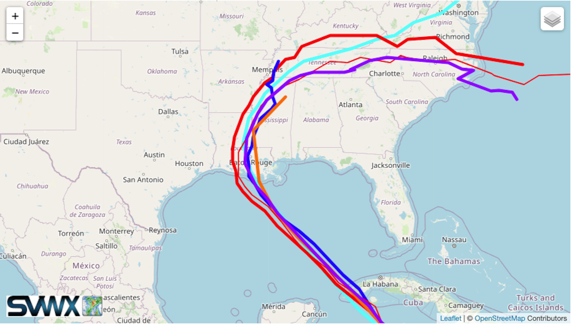
The big picture: Computer models are in agreement on the storm’s general track and evolution of its intensity, with all of the reliable models projecting potentially rapid intensification — in which Ida’s wind speeds would increase by at least 35 mph in 24 hours, potentially all the way up to landfall.
Details: A combination of warmer than average water temperatures for this time of year — which is already the climatological peak for water temperatures in that region — plus a favorable atmospheric setup for intensification means the Gulf could serve as gasoline added to a fire for Ida, with all models showing a large amount of intensification.
- The storm is forecast to become a major hurricane by the time it makes landfall somewhere in coastal Louisiana, with significant and potentially extreme impacts expected for the New Orleans metro area.
- The storm is expected to move relatively quickly toward land, meaning that residents only have about 24 to 36 hours to complete preparations and evacuations before the storm's impacts begin.
Yes, but: Uncertainty still exists on the exact landfall location, with some models taking the storm into central or western Louisiana, the same region hit hard by three storms last season.
- That scenario could spare New Orleans the worst of the winds and storm surge flooding, but the storm surge barriers built in the wake of Katrina may not be able to fully withstand a direct hit by Ida should the storm intensify by a greater amount than currently forecast.
The only clear impediment to the storm as of Friday morning is the possibility that the terrain of Cuba could disrupt its inner circulation for a period of time Friday into Friday night, delaying intensification and therefore putting a lower lid on its intensity at landfall.
Threat level: Water is a big threat with this storm, with initial projections showing a storm surge of 7 to 11 feet above normally dry ground in coastal Louisiana, and up to 15 inches of rainfall likely even well inland.
- While landfall is not forecast until Sunday evening or early Monday, weather conditions will deteriorate along the Gulf Coast during the day Sunday.
- Oil companies have already begun evacuating personnel from Gulf drilling platforms, and the storm may prompt infrastructure shutdowns along the coast, though little to no gas price impacts are likely from this storm.
Context: According to the latest U.N. IPCC report, stronger hurricanes are becoming more common as the climate warms due to human emissions of greenhouse gases, and such storms are also producing more rainfall as air and sea temperatures warm.
- Sea level rise is making such storms more damaging as well. The combination of sea level rise and land subsidence in coastal Louisiana makes such a trend particularly problematic.
- Scientists have also shown that rapid intensification may be linked to climate change, with more storms exhibiting such leaps in storm categories.